
Google Maps now shows a location's air quality on Android and iOS
Google Maps has got a useful feature, which will let you see the air quality of a place you are searching. This functionality will help you find out the air quality of a place before you visit it, thus, helping you decide if you really want to go there. Here's how you can use it.

View air quality on Google Maps now
Air Quality Index (AQI) is a new map layer in Google Maps and can be enabled on either Android or iOS. So, if you search a place for directions or any other information, you can turn on the layer and see the air quality of that place and even nearby places.
Just tap the circular button placed on the bottom right of the search bar and it will open different map layers. One of them is air quality. Once activated, you will see colored dots at various locations. Red for very unhealthy, yellow and orange for unhealthy, and green for healthy air quality. Have a look at how it looks.
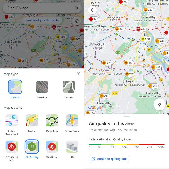
Selecting a specific region to view air quality will provide you with an option to view more information on that topic. Air quality data is provided by the Environmental Protection Agency and PurpleAir in the US, it comes from the National AQI, CPCB (Central Pollution Control Board).
Also available on PurpleAir's AQI Nest devices. For those who don't know, Google introduced AQI functionality to Nest Hub last year.
In addition to this, Google Maps also has wildfire layers, which will show details of active fires in the surrounding area. The data is taken from the National Interagency Fire Center (NIFC). It's also live now. And smoke data will also be added to Google Maps of the United States.
The ability to view air quality on Google Maps is now live for all users. Make sure to update the Google Maps app to get access to it, and when you do, be sure to let us know what you think about it in the comments below.